During the trip we managed to cover 292 kilometers (182 miles) on dog sled, being on the trail for almost 33 hours (counting from starting to move from one camp to stopping at the next camp, so this includes short stops on the trail).
Our average was speed of about 8.9 km/h (about 5.5 miles/hour). (As far as I can tell, the average speed while actually moving was around 9.5 km/h. The lower average above resulted from the breaks during the day.)
The details for the individual days are:
| From | To | Time | Distance |
| Ice Road | Edward's Cabin | 0:30 | 4.51 km |
| Edward's Cabin | Shallow Bay | 5:47 | 49.81 km |
| Shallow Bay | Shingle Point | 10:29 | 88.39 km |
| Shingle Point | Blizzard Camp | 6:11 | 54.37 km |
| Blizzard Camp | Shallow Bay | 4:25 | 40.75 km |
| Shallow Bay | Edward's Cabin | 5:06 | 49.88 km |
| Edward's Cabin | Ice Road | 0:26 | 4.73 km |
| Total | 32:54 | 292.44 km |
The distance covered was a bit less than planned (it's about twice that distance if you go all the way from Inuvik to Herschel Island and back), but, realistically, there were only five days of dog sledding (ignoring the short half-hour runs on the first and the last day).
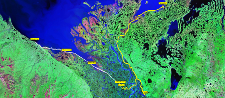
Here's the trail shown over a satellite image of the area (and a grayscale version, since it's easier to see the trail on that one). The yellow trail is the one covered by car on the ice road, the other one is the dogsledding trail.
For anyone who wants to see the trail interactively and in more detail, here's a version
that works with Google Earth:
The route of the dogsledding part of the trip (as a Google Earth KML file) is here.
The route of the Ice Road part of the trip (as a Google Earth KML file) is here.
Here's are the trails shown over a map of the area.
Finally, there are the dog reports.
We were asked by Frank to write a report about 'our' dogs. The reasoning behind that is that the people leading the tours don't get to interact much with the dogs during tourist season, since it's the clients who do the dog sledding (except in rare cases like when Alan took over Chuck's sled). So after spending some time with the dogs, clients might know more about the behavior of the dogs on the trail than Alan or Frank do.
And usually that knowledge gets lost once the trip is over and the tourist leave. So having them write down anything they noticed about the dogs helps in setting up good dog teams for future trips.
But I got a bit bored when doing the reports and had a bit of time on my hands while sitting in the hotel room and waiting for the next time to feed the dogs, so I did the report in 'baseball card' style.
Another reason was doing that was having an example of the information that I would have loved to have at the start of the trip. On the first day, you don't really know your dogs, so you need to ask Frank or Alan to identify your dogs a couple of time. And I am still not able to look at a dog leg and figure out which bootie size would be right, so I wrote down the bootie size and memorized that.
So getting 'info cards' on your dogs at the beginning of the trip would be really convenient. (And I assume that people that go dog sledding (even, or maybe especially, on day tours) would love getting a couple of 'collectible cards' of 'their' dog team. It would be a nice (and easily transportable) memory to rake home and might even get people to 'collect the full set' on subsequent trips
But, be that as it may, here are the report card of 'my' dogs on this trip.